Calheta · South coast
Calheta: golden sand on the south-west coast, and a long drive
The short answer
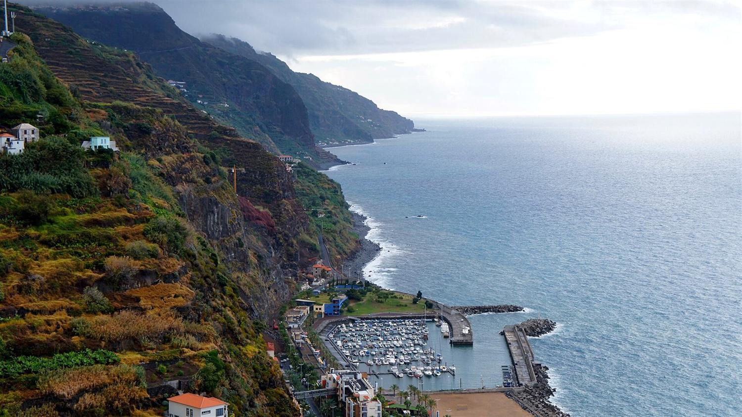
Calheta is a south-west coast town built around one of Madeira’s two imported golden-sand beaches, with a marina and an arts centre. Its centro de saúde runs urgent care around the clock. It is the largest municipality in the archipelago by area, and one of the oldest by population profile.
Calheta parish, resident population
3,188
Censos 2021, Quadro 10. Parish, not municipality.
DREM / INE, 2021 · check it · read August 26, 2026Population change, Calheta parish, 2011 to 2021
+0.8%
One of only seven Madeiran parishes to gain population over the decade.
DREM — Direção Regional de Estatística da Madeira, 2021 · check it · read August 26, 2026Population change, Calheta municipality, 2011 to 2021
−5.3%
The parish grew while the municipality around it shrank.
DREM — Direção Regional de Estatística da Madeira, 2021 · check it · read August 26, 2026Calheta municipality, estimated population
11,611
DREM estimate at 31 December 2025.
DREM — Direção Regional de Estatística da Madeira, 31 December 2025 · check it · read August 26, 2026Population density, Calheta municipality, 2025
104.1 per km²
The fourth lowest on Madeira island.
DREM — Direção Regional de Estatística da Madeira, 31 December 2025 · check it · read August 26, 2026Ageing index, Calheta municipality, 2025
226.5
Residents aged 65 and over per 100 aged 0–14.
DREM — Direção Regional de Estatística da Madeira, 31 December 2025 · check it · read August 26, 202610 more sourced figures on this page
Ageing index, Autonomous Region of Madeira, 2025
186.5
For comparison.
DREM — Direção Regional de Estatística da Madeira, 31 December 2025 · check it · read August 26, 2026Share of Madeira’s non-EU foreign residents living in Calheta, 2021
7.9%
Third in the region, behind Funchal at 43.7% and Câmara de Lobos at 8.3%.
DREM — Direção Regional de Estatística da Madeira, 2021 · check it · read August 26, 2026Annual rainfall, Ponta do Pargo, 2025
558.4 mm
413.2 mm in 2024. The nearest published station inside the municipality, at its far western tip.
DREM — Direção Regional de Estatística da Madeira · check it · read August 26, 2026Mean annual air temperature, Ponta do Pargo, 2025
18.4 °C
19.1 °C in 2024.
DREM — Direção Regional de Estatística da Madeira · check it · read August 26, 2026Mean wind speed, Ponta do Pargo, 2025
11.1 km/h
Predominant direction SW.
DREM — Direção Regional de Estatística da Madeira · check it · read August 26, 2026Calheta to Funchal, modelled
36 minutes
OSRM free-flow output over 33.0 km. Not a measured journey.
OSRM over OpenStreetMap data · check it · read August 26, 2026Calheta to Madeira Airport, modelled
49 minutes
OSRM free-flow output over 49.4 km, to the departures forecourt on Avenida das Partidas. Not a measured journey.
OSRM over OpenStreetMap data · check it · read August 28, 2026Calheta municipality, area
116 km²
The largest municipality in the archipelago, across eight parishes. DREM published density and population for the same municipality imply 111.5 km² rather than this figure.
Câmara Municipal da Calheta · check it · read August 26, 2026Share of Madeira island’s surface in Calheta municipality
15%
As the municipality states it.
Câmara Municipal da Calheta · check it · read August 26, 2026Health centres with an urgência, out of all SESARAM health centres
9 of 47
Calheta is one of the eight that run 24 hours.
SESARAM · check it · read August 26, 2026Calheta is the sunny end of the island, and the far end of it. The town has a marina, an arts centre and a beach of imported golden sand, which on a coast of black shingle is a genuine difference rather than a marketing one.
What comes with it is distance. This is the largest municipality in the archipelago, most of it rural and steep, and everything urban is at the other end of the expressway.
What is actually in the town
Centro de Saúde da Calheta, on Estrada Regional 222, opens on weekdays and runs a Serviço de Urgência twenty-four hours a day, every day. It is one of 9 of 47, source: SESARAM, read August 26, 2026 SESARAM health centres with an urgência at all, which for a town this far west is the most important line on the page. The region’s only twenty-four-hour hospital emergency department is still in Funchal.
There is a Pingo Doce Super Calheta in the vila. Neither chain lists a Continente here, and Lidl has no store anywhere in the archipelago. Schooling runs from a primary with pre-school to Escola Básica e Secundária com Pré-escolar da Calheta.
Buses run the Funchal–Porto Moniz service via Calheta plus several local circuits. Every route number on the island changed to three digits on 9 March 2026, and some old numbers now belong to a different route entirely, so these are the numbers as checked in 2026.
The weather, and which station it comes from
There is no published station in Calheta town. The nearest inside the municipality is Ponta do Pargo, at the far western tip, which recorded 558.4 mm, source: DREM — Direção Regional de Estatística da Madeira, read August 26, 2026 of rain in 2025, a mean annual air temperature of 18.4 °C, source: DREM — Direção Regional de Estatística da Madeira, read August 26, 2026 and mean wind of 11.1 km/h, source: DREM — Direção Regional de Estatística da Madeira, read August 26, 2026.
That is the driest station total quoted anywhere on this site except the eastern tip, and it is a fair guide to the regime rather than a measurement of the town. The municipality rises steeply behind the coast, so cloud and rainfall increase sharply within a very few kilometres inland — the same pattern the regional water-resources study describes for the island as a whole.
Who lives here
Calheta parish counted 3,188, source: DREM / INE, 2021, read August 26, 2026 residents at the 2021 census and grew +0.8%, source: DREM — Direção Regional de Estatística da Madeira, 2021, read August 26, 2026 across the census decade — one of only seven Madeiran parishes to gain population at all — while the municipality as a whole fell −5.3%, source: DREM — Direção Regional de Estatística da Madeira, 2021, read August 26, 2026.
DREM estimates the municipality at 11,611, source: DREM — Direção Regional de Estatística da Madeira, 31 December 2025, read August 26, 2026 at the end of 2025, with a density of 104.1 per km², source: DREM — Direção Regional de Estatística da Madeira, 31 December 2025, read August 26, 2026 and an ageing index of 226.5, source: DREM — Direção Regional de Estatística da Madeira, 31 December 2025, read August 26, 2026 against 186.5, source: DREM — Direção Regional de Estatística da Madeira, 31 December 2025, read August 26, 2026 regionally. Calheta is also the third concentration of non-EU foreign residents in the region, holding 7.9%, source: DREM — Direção Regional de Estatística da Madeira, 2021, read August 26, 2026 of them at the 2021 census, behind Funchal and Câmara de Lobos.
The drive
Modelled at free-flow speed over OpenStreetMap data, Funchal is 36 minutes, source: OSRM over OpenStreetMap data, read August 26, 2026 and the airport 49 minutes, source: OSRM over OpenStreetMap data, read August 28, 2026. These are routing-engine outputs with no traffic and no parking allowance in them.
The airport figure is the one that catches people. Calheta to the terminal is close to an hour on the model alone, which changes what an early flight looks like and what a visiting family costs in car hire.
The municipality, and a trap worth knowing
Calheta is the largest municipality in the archipelago, covering 116 km², source: Câmara Municipal da Calheta, read August 26, 2026 — around 15%, source: Câmara Municipal da Calheta, read August 26, 2026 of Madeira island’s surface — across eight parishes: Arco da Calheta, Calheta, Estreito da Calheta, Jardim do Mar, Paul do Mar, Prazeres, Fajã da Ovelha and Ponta do Pargo. The municipal holiday is 24 June.
One practical warning, because it catches researchers as well as buyers. The municipal site is cmcalheta.pt. The similar-looking cm-calheta.pt belongs to Calheta on São Jorge, in the Azores — a different municipality in a different archipelago. The Madeiran municipality’s own page also still quotes the 2011 census for population, which is why every population figure here comes from DREM instead.
Who it does not suit
Commuters — the modelled run to Funchal is well over half an hour before any traffic, the airport is close to an hour away, and the municipality has one of the oldest population profiles in the region.
Questions people actually ask
Does Calheta have 24-hour urgent care?
Yes. Centro de Saúde da Calheta runs a Serviço de Urgência twenty-four hours a day, every day, one of only 9 of 47, source: SESARAM, read August 26, 2026 SESARAM health centres with an urgência at all. It is not a hospital. The region’s only twenty-four-hour hospital emergency department is in Funchal, a modelled 36 minutes, source: OSRM over OpenStreetMap data, read August 26, 2026 away with no traffic in the figure.
How long is the drive from Calheta to the airport?
49 minutes, source: OSRM over OpenStreetMap data, read August 28, 2026 on the model — a routing engine at free-flow speed over OpenStreetMap data, with no traffic, roadworks or parking. Funchal is 36 minutes, source: OSRM over OpenStreetMap data, read August 26, 2026. Anyone flying often should treat the airport figure as the real cost of living at this end of the island.
Is Calheta beach real sand?
It is imported golden sand, one of two such beaches on Madeira, on a coast that is otherwise black shingle and rock. The municipality is the source for the beach; this page carries no claim about water quality, crowding or season, because no source consulted published one.
Is Calheta the sunniest part of Madeira?
No source consulted supports that as a measurement. Only three stations in the archipelago publish sunshine hours, and none of them is in Calheta municipality. What is published is rainfall and temperature at Ponta do Pargo, at the municipality’s western tip: 558.4 mm, source: DREM — Direção Regional de Estatística da Madeira, read August 26, 2026 and 18.4 °C, source: DREM — Direção Regional de Estatística da Madeira, read August 26, 2026 in 2025. That is a dry regime, and it is as far as the evidence goes.
Where this came from
- SESARAM: Diretório de serviços — centros de saúde. sesaram.pt/portal/utente/diretorio-de-servicos/centr Read August 26, 2026.
- SESARAM: Urgência — horário dos serviços. sesaram.pt/portal/utente/urgencia/horario-dos-servic Read August 26, 2026.
- Governo Regional da Madeira: Dados dos estabelecimentos de ensino, 2024/2025. place.madeira.gov.pt/place21/nStyles/Bootstrap/img/assets/Dado Read August 26, 2026.
- SIGA, Governo Regional da Madeira: Renumeração das carreiras para três dígitos, em vigor desde 09/03/2026. siga.madeira.gov.pt/noticias/show/2069 Read August 26, 2026.
- Pingo Doce: Store locator API (national store list). pingodoce.pt/wp-content/themes/pingodoce/ajax/pd-ajax. Read August 26, 2026.
- Governo Regional da Madeira (portal da geodiversidade): Prada et al., Disponibilidades Hídricas da Ilha da Madeira. geodiversidade.madeira.gov.pt/images/documentos/Publicacoes/Madeira/Dis Read August 26, 2026.
- Câmara Municipal da Calheta: Município — o concelho — história. cmcalheta.pt/pt/municipio/concelho/historia Read August 26, 2026.
- DREM / INE: Censos 2021, resultados definitivos — Quadro 10, resident population by geographic location. estatistica.madeira.gov.pt/en/download-now-3/social-gb/popcondsoc-gb Read August 26, 2026.
- DREM — Direção Regional de Estatística da Madeira: Em Foco — Censos 2021, Resultados Definitivos. estatistica.madeira.gov.pt/download-now/social/popcondsoc-pt/popcond Read August 26, 2026.
- DREM — Direção Regional de Estatística da Madeira: População e indicadores demográficos por município em 2025. estatistica.madeira.gov.pt/download-now/social/popcondsoc-pt/demogra Read August 26, 2026.
- DREM — Direção Regional de Estatística da Madeira: Precipitação anual, 2000–2025 (série retrospetiva, dados meteorológicos). estatistica.madeira.gov.pt/download-now/ambiente-territorio/dados-me Read August 26, 2026.
- DREM — Direção Regional de Estatística da Madeira: Temperatura do ar anual, 2000–2025 (série retrospetiva, dados meteorológicos). estatistica.madeira.gov.pt/download-now/ambiente-territorio/dados-me Read August 26, 2026.
- DREM — Direção Regional de Estatística da Madeira: Velocidade e rumo do vento, 2012–2025 (série retrospetiva, dados meteorológicos). estatistica.madeira.gov.pt/download-now/ambiente-territorio/dados-me Read August 26, 2026.
- OSRM over OpenStreetMap data: Free-flow driving route — modelled output, not a measured journey. router.project-osrm.org/route/v1/driving/-17.1782577,32.7219412;- Read August 26, 2026.
- OSRM over OpenStreetMap data: Free-flow driving route — modelled output, not a measured journey. router.project-osrm.org/route/v1/driving/-17.1782577,32.7219412;- Read August 28, 2026.