Ribeira Brava · South coast
Ribeira Brava: the junction, and what a junction costs
The short answer
Ribeira Brava sits at the mouth of a major valley on the south coast, where the coastal expressway meets the road north over the mountains. It has round-the-clock urgent care, three chain supermarkets and schooling to secondary, and it lost less population across the census decade than almost anywhere in the region.
Ribeira Brava parish, resident population
6,232
Censos 2021, Quadro 10. Parish, not municipality.
DREM / INE, 2021 · check it · read August 26, 2026Ribeira Brava municipality, estimated population
13,172
DREM estimate at 31 December 2025.
DREM — Direção Regional de Estatística da Madeira, 31 December 2025 · check it · read August 26, 2026Population change, Ribeira Brava municipality, 2011 to 2021
−5.2%
The second-smallest fall of any Madeiran municipality, after Santa Cruz.
DREM — Direção Regional de Estatística da Madeira, 2021 · check it · read August 26, 2026Population change, Autonomous Region of Madeira, 2011 to 2021
−6.4%
For comparison.
DREM — Direção Regional de Estatística da Madeira, 2021 · check it · read August 26, 2026Population density, Ribeira Brava municipality, 2025
201.2 per km²
DREM estimate.
DREM — Direção Regional de Estatística da Madeira, 31 December 2025 · check it · read August 26, 2026Ageing index, Ribeira Brava municipality, 2025
192.7
Against 186.5 regionally.
DREM — Direção Regional de Estatística da Madeira, 31 December 2025 · check it · read August 26, 20266 more sourced figures on this page
Annual rainfall, Quinta Grande, 2025
711.5 mm
498.6 mm in 2024. The nearest published station, and it sits above sea level.
DREM — Direção Regional de Estatística da Madeira · check it · read August 26, 2026Mean annual air temperature, Quinta Grande, 2025
17.6 °C
18.5 °C in 2024.
DREM — Direção Regional de Estatística da Madeira · check it · read August 26, 2026Ribeira Brava to Funchal, modelled
24 minutes
OSRM free-flow output over 20.3 km. Not a measured journey.
OSRM over OpenStreetMap data · check it · read August 26, 2026Ribeira Brava to Madeira Airport, modelled
37 minutes
OSRM free-flow output over 36.7 km, to the departures forecourt on Avenida das Partidas. Not a measured journey.
OSRM over OpenStreetMap data · check it · read August 28, 2026Ribeira Brava municipality, area
65 km²
Approximate, as the municipality states it. Four parishes.
Câmara Municipal da Ribeira Brava · check it · read August 26, 2026Health centres with an urgência, out of all SESARAM health centres
9 of 47
Ribeira Brava is one of the eight that run 24 hours.
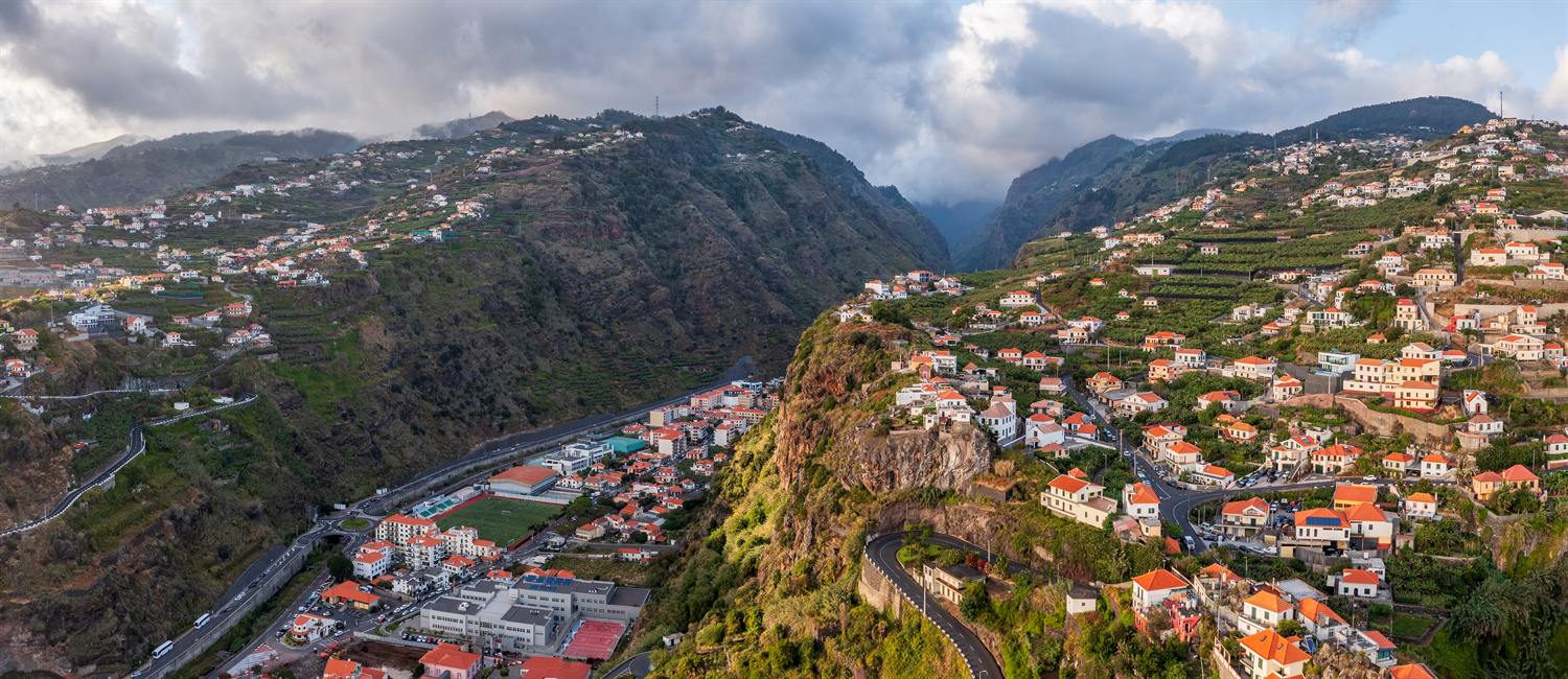
SESARAM · check it · read August 26, 2026Ribeira Brava is where the island’s road network makes up its mind. The coastal expressway runs past it and the road north over the mountains starts here, which is why the town has more services than its size would suggest and more traffic than its residents would like.
It is also one of the few Madeiran municipalities that has held onto its population.
What is actually in the town
Centro de Saúde da Ribeira Brava, on Estrada Regional 104, opens on weekdays and runs a Serviço de Atendimento Urgente twenty-four hours a day, every day — one of 9 of 47, source: SESARAM, read August 26, 2026 SESARAM health centres with an urgência at all. As everywhere outside the capital, that is urgent care rather than a hospital emergency department, and how the regional service is arranged is worth understanding before it matters.
Shopping is unusually good: Pingo Doce Super Ribeira Brava on Estrada Comandante Camacho de Freitas, plus two Continente Modelo stores. Lidl has no store anywhere in the archipelago. Schooling runs from a primary with pre-school at Lombo de São João to Escola Básica e Secundária Padre Manuel Álvares.
The bus provision reflects the junction. Funchal is served both by expressway and by the old Estrada Regional, and a long list of local routes fans out from the town. All Madeiran route numbers changed to a three-digit scheme on 9 March 2026.
The weather, and the road that changes it
The nearest published station is Quinta Grande, which recorded 711.5 mm, source: DREM — Direção Regional de Estatística da Madeira, read August 26, 2026 of rain in 2025 and a mean annual air temperature of 17.6 °C, source: DREM — Direção Regional de Estatística da Madeira, read August 26, 2026. That station sits well above sea level, so it reads cooler than the seafront here.
What makes this town’s weather worth thinking about is the road behind it. The route north climbs out of this valley and over the ridge, so conditions a few kilometres inland are not the conditions in the town — the regional water-resources study puts the rise in rainfall with altitude as rapid up to roughly six hundred metres. A driver leaving Ribeira Brava in sunshine can be in cloud before the pass.
Who lives here
Ribeira Brava parish counted 6,232, source: DREM / INE, 2021, read August 26, 2026 residents at the 2021 census. The municipality fell only −5.2%, source: DREM — Direção Regional de Estatística da Madeira, 2021, read August 26, 2026 across the census decade, the second-smallest fall of any Madeiran municipality after Santa Cruz, against −6.4%, source: DREM — Direção Regional de Estatística da Madeira, 2021, read August 26, 2026 for the region.
DREM estimates it at 13,172, source: DREM — Direção Regional de Estatística da Madeira, 31 December 2025, read August 26, 2026 at the end of 2025, with a density of 201.2 per km², source: DREM — Direção Regional de Estatística da Madeira, 31 December 2025, read August 26, 2026 and an ageing index of 192.7, source: DREM — Direção Regional de Estatística da Madeira, 31 December 2025, read August 26, 2026. The municipality gives its own area as 65 km², source: Câmara Municipal da Ribeira Brava, read August 26, 2026 across four parishes — Campanário, Ribeira Brava, Serra de Água and Tabua — bordered by Câmara de Lobos to the east, Ponta do Sol to the west and São Vicente to the north.
The drive
Modelled at free-flow speed, Funchal is 24 minutes, source: OSRM over OpenStreetMap data, read August 26, 2026 and the airport 37 minutes, source: OSRM over OpenStreetMap data, read August 28, 2026. Both figures come from a routing engine over OpenStreetMap data, with no traffic in them, which for a through-town on the island’s main west-bound artery is a real omission rather than a technicality.
Who it does not suit
Anyone wanting seclusion — it is a busy through-town, and the valley funnels both the traffic and, in heavy weather, the water.
Questions people actually ask
Does Ribeira Brava have an urgência?
Yes, around the clock. The Serviço de Atendimento Urgente at Centro de Saúde da Ribeira Brava runs twenty-four hours a day, every day, one of only 9 of 47, source: SESARAM, read August 26, 2026 SESARAM health centres with an urgência at all. It is not a hospital emergency department; the only one of those in the region is at Hospital Dr. Nélio Mendonça in Funchal.
Is Ribeira Brava a good base for the west of the island?
Geographically it is the junction: the coastal expressway runs through it and the road north over the mountains starts here. That produces good bus provision — Funchal by two different roads, plus a long list of local routes — and constant through traffic. The modelled drive to Funchal is 24 minutes, source: OSRM over OpenStreetMap data, read August 26, 2026, with no traffic in the figure.
Is Ribeira Brava losing population?
Less than almost anywhere in the region. The municipality fell −5.2%, source: DREM — Direção Regional de Estatística da Madeira, 2021, read August 26, 2026 between the 2011 and 2021 censuses against −6.4%, source: DREM — Direção Regional de Estatística da Madeira, 2021, read August 26, 2026 regionally, the second-smallest fall on the island after Santa Cruz. DREM’s estimate for the end of 2025 is 13,172, source: DREM — Direção Regional de Estatística da Madeira, 31 December 2025, read August 26, 2026, at a density of 201.2 per km², source: DREM — Direção Regional de Estatística da Madeira, 31 December 2025, read August 26, 2026.
Does the valley flood?
The town sits at the mouth of a major valley, and a valley mouth is where water arrives. No flood record, return period or risk map was published by any source used for this page, so this site puts no figure on it. The geography is stated because it is a question worth asking a surveyor rather than a website.
Where this came from
- SESARAM: Diretório de serviços — centros de saúde. sesaram.pt/portal/utente/diretorio-de-servicos/centr Read August 26, 2026.
- SESARAM: Urgência — horário dos serviços. sesaram.pt/portal/utente/urgencia/horario-dos-servic Read August 26, 2026.
- Governo Regional da Madeira: Dados dos estabelecimentos de ensino, 2024/2025. place.madeira.gov.pt/place21/nStyles/Bootstrap/img/assets/Dado Read August 26, 2026.
- SIGA, Governo Regional da Madeira: Renumeração das carreiras para três dígitos, em vigor desde 09/03/2026. siga.madeira.gov.pt/noticias/show/2069 Read August 26, 2026.
- Pingo Doce: Store locator API (national store list). pingodoce.pt/wp-content/themes/pingodoce/ajax/pd-ajax. Read August 26, 2026.
- Continente: Lojas — Madeira. feed.continente.pt/lojas/madeira Read August 26, 2026.
- Governo Regional da Madeira (portal da geodiversidade): Prada et al., Disponibilidades Hídricas da Ilha da Madeira. geodiversidade.madeira.gov.pt/images/documentos/Publicacoes/Madeira/Dis Read August 26, 2026.
- Câmara Municipal da Ribeira Brava: Geografia. cm-ribeirabrava.pt/geografia/ Read August 26, 2026.
- DREM / INE: Censos 2021, resultados definitivos — Quadro 10, resident population by geographic location. estatistica.madeira.gov.pt/en/download-now-3/social-gb/popcondsoc-gb Read August 26, 2026.
- DREM — Direção Regional de Estatística da Madeira: População e indicadores demográficos por município em 2025. estatistica.madeira.gov.pt/download-now/social/popcondsoc-pt/demogra Read August 26, 2026.
- DREM — Direção Regional de Estatística da Madeira: Em Foco — Censos 2021, Resultados Definitivos. estatistica.madeira.gov.pt/download-now/social/popcondsoc-pt/popcond Read August 26, 2026.
- DREM — Direção Regional de Estatística da Madeira: Precipitação anual, 2000–2025 (série retrospetiva, dados meteorológicos). estatistica.madeira.gov.pt/download-now/ambiente-territorio/dados-me Read August 26, 2026.
- DREM — Direção Regional de Estatística da Madeira: Temperatura do ar anual, 2000–2025 (série retrospetiva, dados meteorológicos). estatistica.madeira.gov.pt/download-now/ambiente-territorio/dados-me Read August 26, 2026.
- OSRM over OpenStreetMap data: Free-flow driving route — modelled output, not a measured journey. router.project-osrm.org/route/v1/driving/-17.0650395,32.6700921;- Read August 26, 2026.
- OSRM over OpenStreetMap data: Free-flow driving route — modelled output, not a measured journey. router.project-osrm.org/route/v1/driving/-17.0650395,32.6700921;- Read August 28, 2026.