Santana · North coast
Santana: the wettest town on this site, by a long way
The short answer
Santana is the main town of Madeira’s north coast and the only city on that side of the island. It recorded nearly twice Funchal’s rainfall in 2025, the fewest dry days of any Madeiran station, and the steepest population fall of any municipality in the region. Its whole municipality is a UNESCO Biosphere Reserve.
Annual rainfall, Santana station, 2025
1,228.4 mm
1,020.8 mm in 2024.
DREM — Direção Regional de Estatística da Madeira · check it · read August 26, 2026Annual rainfall, Funchal/Observatório, 2025
669.7 mm
Same year, opposite side of the ridge.
DREM — Direção Regional de Estatística da Madeira · check it · read August 26, 2026Annual rainfall, Funchal/Lido, 2025
348.5 mm
The lowest station total on the island that year.
DREM — Direção Regional de Estatística da Madeira · check it · read August 26, 2026Mean annual air temperature, Santana, 2025
16.2 °C
17.0 °C in 2024. The station sits several hundred metres above the sea.
DREM — Direção Regional de Estatística da Madeira · check it · read August 26, 2026Days without precipitation, Santana, 2024
140
The fewest of any Madeiran station that year.
DREM — Direção Regional de Estatística da Madeira · check it · read August 26, 2026Days with 1 mm or more of rain, Santana, 2024
129
The most of any Madeiran station that year.
DREM — Direção Regional de Estatística da Madeira · check it · read August 26, 202611 more sourced figures on this page
Santana parish, resident population
2,838
Censos 2021, Quadro 10. The municipality total was 6,553.
DREM / INE, 2021 · check it · read August 26, 2026Santana municipality, estimated population
6,643
DREM estimate at 31 December 2025.
DREM — Direção Regional de Estatística da Madeira, 31 December 2025 · check it · read August 26, 2026Population change, Santana municipality, 2011 to 2021
−15.1%
From 7,719 to 6,553. The steepest fall of any Madeiran municipality.
DREM — Direção Regional de Estatística da Madeira, 2021 · check it · read August 26, 2026Population density, Santana municipality, 2025
69.6 per km²
Among the three least dense municipalities in the region.
DREM — Direção Regional de Estatística da Madeira, 31 December 2025 · check it · read August 26, 2026Growth in vacant dwellings, Santana, 2011 to 2021
+80.6%
The steepest increase in the region.
DREM — Direção Regional de Estatística da Madeira, 2021 · check it · read August 26, 2026Ageing index, Santana municipality, 2025
306.2
The second oldest municipal profile in the region, after Porto Moniz at 310.5.
DREM — Direção Regional de Estatística da Madeira, 31 December 2025 · check it · read August 26, 2026Ground elevation at the centre point of Santana
426 m
Terrain within about 700 m of that point runs 348 m to 497 m. Not the full parish.
Copernicus DEM GLO-90 via the Open-Meteo elevation API · check it · read August 26, 2026Altitude of the concelho, as the municipality states it
312 m
The municipality’s own figure for the concelho, which differs from the model sample at the town centre.
Santana Madeira Biosfera (Câmara Municipal de Santana) · check it · read August 26, 2026Santana to Funchal, modelled
42 minutes
OSRM free-flow output over 39.8 km. Not a measured journey.
OSRM over OpenStreetMap data · check it · read August 26, 2026Santana to Madeira Airport, modelled
24 minutes
OSRM free-flow output over 21.7 km, to the departures forecourt on Avenida das Partidas. Not a measured journey. Closer than the capital.
OSRM over OpenStreetMap data · check it · read August 28, 2026Health centres with an urgência, out of all SESARAM health centres
9 of 47
Santana is one of the eight that run 24 hours.
SESARAM · check it · read August 26, 2026Santana is where the north coast stops being scenery and becomes a place with services in it. It has round-the-clock urgent care, a supermarket, and a single school that takes a child from creche to the end of secondary — which on this side of the island is a real advantage.
It is also the wettest inhabited place covered on this site, and the numbers are not marginal.
The rainfall is the story, and it is measured
The Santana station recorded 1,228.4 mm, source: DREM — Direção Regional de Estatística da Madeira, read August 26, 2026 of rain in 2025. Funchal/Observatório recorded 669.7 mm, source: DREM — Direção Regional de Estatística da Madeira, read August 26, 2026 in the same year, and Funchal/Lido 348.5 mm, source: DREM — Direção Regional de Estatística da Madeira, read August 26, 2026. That is roughly two to three and a half times as much rain, depending which Funchal station is used, measured in the same year by the same regional statistics office.
The frequency matters as much as the total. In 2024 Santana had 140, source: DREM — Direção Regional de Estatística da Madeira, read August 26, 2026 days without precipitation, the fewest of any Madeiran station, and 129, source: DREM — Direção Regional de Estatística da Madeira, read August 26, 2026 days with measurable rain, the most. Mean annual air temperature was 16.2 °C, source: DREM — Direção Regional de Estatística da Madeira, read August 26, 2026 in 2025, which reflects both the northern aspect and the town’s position several hundred metres above the sea. The full north–south comparison puts those numbers alongside the rest of the island.
What is actually in the town
Centro de Saúde de Santana, on Avenida Manuel Marques da Trindade, opens on weekdays and runs a Serviço de Atendimento Urgente twenty-four hours a day, every day. It is one of 9 of 47, source: SESARAM, read August 26, 2026 SESARAM health centres with an urgência at all. The region’s only twenty-four-hour hospital emergency department is in Funchal, on the far side of the ridge.
There is a Continente Modelo at Sítio do Barreiro. Lidl has no store anywhere in the archipelago. Schooling is unusually convenient: Escola Básica e Secundária com Pré-escolar e Creche Bispo D. Manuel Ferreira Cabral covers creche to secondary in one establishment, so a family here does not change school buildings as children age.
Buses run on the Funchal–Santana trunk route plus services to Porto da Cruz and two local circuits. All Madeiran route numbers changed to a three-digit scheme on 9 March 2026, so older lists are unreliable.
Who lives here, and who has left
Santana parish counted 2,838, source: DREM / INE, 2021, read August 26, 2026 residents at the 2021 census. The municipality fell −15.1%, source: DREM — Direção Regional de Estatística da Madeira, 2021, read August 26, 2026 across the census decade, the steepest fall of any Madeiran municipality, and DREM estimates it at 6,643, source: DREM — Direção Regional de Estatística da Madeira, 31 December 2025, read August 26, 2026 at the end of 2025, with a density of 69.6 per km², source: DREM — Direção Regional de Estatística da Madeira, 31 December 2025, read August 26, 2026.
The number a buyer should look at hardest is a different one. Vacant dwellings in Santana grew +80.6%, source: DREM — Direção Regional de Estatística da Madeira, 2021, read August 26, 2026 between the two censuses, the steepest increase in the region. Its ageing index, 306.2, source: DREM — Direção Regional de Estatística da Madeira, 31 December 2025, read August 26, 2026, is the second oldest municipal profile in the region. Neither figure is a forecast about resale, and this site does not make forecasts — but they are the published context in which a purchase here happens.
The Biosphere Reserve, and the thatched houses
UNESCO classified Santana as a Biosphere Reserve under the Man and the Biosphere programme on 29 June 2011. The reserve covers the entire land area of the municipality plus the adjacent sea out to the two-hundred-metre isobath. No area figure is published for it — the reserve is defined by boundary, not by size, and none is invented here.
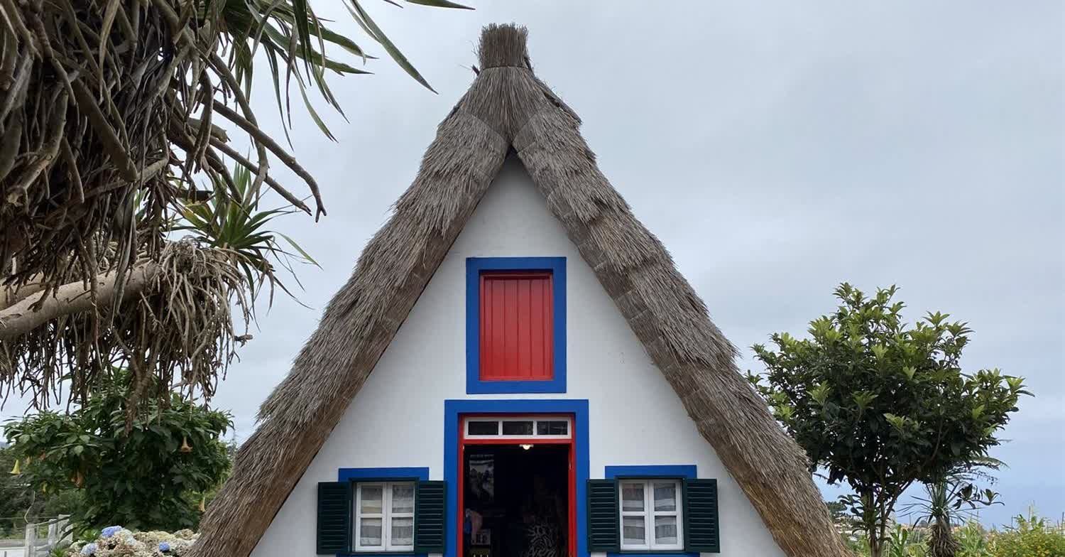
The thatched houses are officially casas de colmo, and the official description gives three roof forms: casas de empena ou de fio, de meio-fio and de quatro águas. The four-sided type, often called casas redondas, was built mainly in São Jorge parish. The municipality has planted wheat and rye on abandoned farmland to keep a supply of thatch. The word triangular, which is the common tourist description, does not appear in the official text.
The drive, and the altitude question
Modelled at free-flow speed over OpenStreetMap data, Funchal is 42 minutes, source: OSRM over OpenStreetMap data, read August 26, 2026 and the airport 24 minutes, source: OSRM over OpenStreetMap data, read August 28, 2026. The airport is closer than the capital from here, and that reverses the usual assumption about the north coast.
On altitude the sources differ and both are recorded. The municipality gives the concelho an altitude of about 312 m, source: Santana Madeira Biosfera (Câmara Municipal de Santana), read August 26, 2026; the elevation model samples the town centre point at 426 m, source: Copernicus DEM GLO-90 via the Open-Meteo elevation API, read August 26, 2026. The model figure describes ground within a few hundred metres of the centre, not the parish, which runs from the sea to the ridge like most of the island.
Who it does not suit
Sun-and-dry buyers, and anyone worried about resale — it recorded nearly twice Funchal’s rainfall in 2025, has one of the region’s two oldest population profiles, and lost more residents across the census decade than any other Madeiran municipality.
Questions people actually ask
How much wetter is Santana than Funchal?
In 2025 the Santana station recorded 1,228.4 mm, source: DREM — Direção Regional de Estatística da Madeira, read August 26, 2026, Funchal/Observatório 669.7 mm, source: DREM — Direção Regional de Estatística da Madeira, read August 26, 2026 and Funchal/Lido 348.5 mm, source: DREM — Direção Regional de Estatística da Madeira, read August 26, 2026 — roughly two to three and a half times as much, depending which Funchal station is used. Santana also had the fewest dry days of any Madeiran station in 2024, at 140, source: DREM — Direção Regional de Estatística da Madeira, read August 26, 2026. All four figures come from the same regional statistics office.
Does Santana have a school for older children?
Yes, and it is unusual in covering every age in one establishment: Escola Básica e Secundária com Pré-escolar e Creche Bispo D. Manuel Ferreira Cabral takes a child from creche to the end of secondary. There is no international or English-language school here. Both of the archipelago’s international schools are in Funchal.
What does the UNESCO Biosphere Reserve status actually cover?
The whole land area of Santana municipality plus the adjacent sea out to the two-hundred-metre isobath, classified under the Man and the Biosphere programme on 29 June 2011. The official source defines the reserve by boundary and publishes no area figure, so none is given here.
Is Santana emptying out?
The municipality lost −15.1%, source: DREM — Direção Regional de Estatística da Madeira, 2021, read August 26, 2026 of its residents between the 2011 and 2021 censuses, the steepest fall in the region, and vacant dwellings grew +80.6%, source: DREM — Direção Regional de Estatística da Madeira, 2021, read August 26, 2026 over the same period, also the steepest in the region. DREM’s 2025 estimate is 6,643, source: DREM — Direção Regional de Estatística da Madeira, 31 December 2025, read August 26, 2026, so the direction has changed. This site makes no projection about what either figure means for a resale.
Where this came from
- SESARAM: Diretório de serviços — centros de saúde. sesaram.pt/portal/utente/diretorio-de-servicos/centr Read August 26, 2026.
- SESARAM: Urgência — horário dos serviços. sesaram.pt/portal/utente/urgencia/horario-dos-servic Read August 26, 2026.
- Governo Regional da Madeira: Dados dos estabelecimentos de ensino, 2024/2025. place.madeira.gov.pt/place21/nStyles/Bootstrap/img/assets/Dado Read August 26, 2026.
- SIGA, Governo Regional da Madeira: Renumeração das carreiras para três dígitos, em vigor desde 09/03/2026. siga.madeira.gov.pt/noticias/show/2069 Read August 26, 2026.
- Continente: Lojas — Madeira. feed.continente.pt/lojas/madeira Read August 26, 2026.
- Santana Madeira Biosfera (Câmara Municipal de Santana): Concelho de Santana. santanamadeirabiosfera.pt/o-que-fazer-e-visitar/atividades/concelho Read August 26, 2026.
- Santana Madeira Biosfera: Biosfera — caraterização da reserva. santanamadeirabiosfera.pt/biosfera/sobre/caraterizacao-smb Read August 26, 2026.
- Santana Madeira Biosfera: Tradições e património — casas de colmo. santanamadeirabiosfera.pt/conhecer/tradicoes-e-patrimonio/casas-de- Read August 26, 2026.
- DREM — Direção Regional de Estatística da Madeira: Precipitação anual, 2000–2025 (série retrospetiva, dados meteorológicos). estatistica.madeira.gov.pt/download-now/ambiente-territorio/dados-me Read August 26, 2026.
- DREM — Direção Regional de Estatística da Madeira: Temperatura do ar anual, 2000–2025 (série retrospetiva, dados meteorológicos). estatistica.madeira.gov.pt/download-now/ambiente-territorio/dados-me Read August 26, 2026.
- DREM — Direção Regional de Estatística da Madeira: Dados Meteorológicos em Foco — 2024. estatistica.madeira.gov.pt/download-now/ambiente-territorio/dados-me Read August 26, 2026.
- DREM / INE: Censos 2021, resultados definitivos — Quadro 10, resident population by geographic location. estatistica.madeira.gov.pt/en/download-now-3/social-gb/popcondsoc-gb Read August 26, 2026.
- DREM — Direção Regional de Estatística da Madeira: População e indicadores demográficos por município em 2025. estatistica.madeira.gov.pt/download-now/social/popcondsoc-pt/demogra Read August 26, 2026.
- DREM — Direção Regional de Estatística da Madeira: Em Foco — Censos 2021, Resultados Definitivos. estatistica.madeira.gov.pt/download-now/social/popcondsoc-pt/popcond Read August 26, 2026.
- Copernicus DEM GLO-90 via the Open-Meteo elevation API: Ground elevation at the centre point and four points about 700 m away. api.open-meteo.com/v1/elevation Read August 26, 2026.
- OSRM over OpenStreetMap data: Free-flow driving route — modelled output, not a measured journey. router.project-osrm.org/route/v1/driving/-16.8813015,32.804907;-1 Read August 26, 2026.
- OSRM over OpenStreetMap data: Free-flow driving route — modelled output, not a measured journey. router.project-osrm.org/route/v1/driving/-16.8813015,32.804907;-1 Read August 28, 2026.